Plan von der Gegend bei Berlin, 1:8 000, 1827
")
")


Titel: Plan von der Gegend bei Berlin
Person: Ernst Heinrich Dannhauer
Maßstab: 1:8 000
Datierung: 1827
Anzahl der Blätter: 80 Sektionen
Format: 46,5 x 42 cm
Technik: Lithographie, koloriert
Signatur: Kart. N 3660
 https://kartenhighlights.staatsbibliothek-berlin.de/wp-content/uploads/SBB_IIIC_Kart_N-5858_Blatt-13_Ausschnitt_web-40000-dpi-scaled.jpg
1552
2560
AL
https://kartenhighlights.staatsbibliothek-berlin.de/wp-content/uploads/2020/11/logoSBB-SPK.svg
AL2023-12-14 10:58:262023-12-14 10:58:26Suchodolec, Ichnographia der Herrschaft Potsdam, ca. 1:12 500, 1683
https://kartenhighlights.staatsbibliothek-berlin.de/wp-content/uploads/SBB_IIIC_Kart_N-5858_Blatt-13_Ausschnitt_web-40000-dpi-scaled.jpg
1552
2560
AL
https://kartenhighlights.staatsbibliothek-berlin.de/wp-content/uploads/2020/11/logoSBB-SPK.svg
AL2023-12-14 10:58:262023-12-14 10:58:26Suchodolec, Ichnographia der Herrschaft Potsdam, ca. 1:12 500, 1683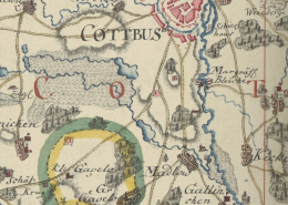 https://kartenhighlights.staatsbibliothek-berlin.de/wp-content/uploads/SBB_IIIC_Kart_N-5435_10_Blatt-13_2Ausschnitt-40000-dpi.jpg
1312
1376
AL
https://kartenhighlights.staatsbibliothek-berlin.de/wp-content/uploads/2020/11/logoSBB-SPK.svg
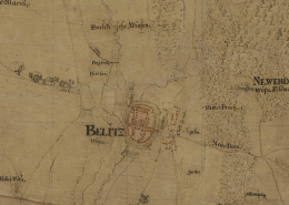
AL2022-04-07 01:00:442023-02-03 16:09:14Von Balbi, Sektionskarten von Brandenburg, 1:75 000, 1748-1749
https://kartenhighlights.staatsbibliothek-berlin.de/wp-content/uploads/SBB_IIIC_Kart_N-5435_10_Blatt-13_2Ausschnitt-40000-dpi.jpg
1312
1376
AL
https://kartenhighlights.staatsbibliothek-berlin.de/wp-content/uploads/2020/11/logoSBB-SPK.svg
AL2022-04-07 01:00:442023-02-03 16:09:14Von Balbi, Sektionskarten von Brandenburg, 1:75 000, 1748-1749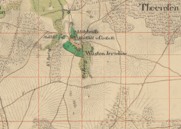 https://kartenhighlights.staatsbibliothek-berlin.de/wp-content/uploads/SBB_IIIC_Kart_N-1036_Blatt-274_Ausschnitt-40000-dpi.jpg
1410
1943
AL
https://kartenhighlights.staatsbibliothek-berlin.de/wp-content/uploads/2020/11/logoSBB-SPK.svg
AL2022-04-06 01:00:162023-01-17 17:04:23Von Decker, Quadratmeilenblätter von Brandenburg, 1:25 000, 1816-1822
https://kartenhighlights.staatsbibliothek-berlin.de/wp-content/uploads/SBB_IIIC_Kart_N-1036_Blatt-274_Ausschnitt-40000-dpi.jpg
1410
1943
AL
https://kartenhighlights.staatsbibliothek-berlin.de/wp-content/uploads/2020/11/logoSBB-SPK.svg
AL2022-04-06 01:00:162023-01-17 17:04:23Von Decker, Quadratmeilenblätter von Brandenburg, 1:25 000, 1816-1822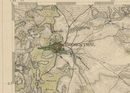 https://kartenhighlights.staatsbibliothek-berlin.de/wp-content/uploads/SBB_IIIC_Kart_N-3643_Blatt-3_Ausschnitt_WEB.jpg
1593
1807
AL
https://kartenhighlights.staatsbibliothek-berlin.de/wp-content/uploads/2020/11/logoSBB-SPK.svg
AL2022-04-05 01:00:592023-02-03 16:11:13Von Decker, Umgegend von Berlin, 1:50 000, 1818-1819
https://kartenhighlights.staatsbibliothek-berlin.de/wp-content/uploads/SBB_IIIC_Kart_N-3643_Blatt-3_Ausschnitt_WEB.jpg
1593
1807
AL
https://kartenhighlights.staatsbibliothek-berlin.de/wp-content/uploads/2020/11/logoSBB-SPK.svg
AL2022-04-05 01:00:592023-02-03 16:11:13Von Decker, Umgegend von Berlin, 1:50 000, 1818-1819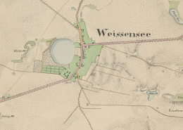 https://kartenhighlights.staatsbibliothek-berlin.de/wp-content/uploads/SBB_IIIC_Kart_N-3660_Blatt-19_Ausschnitt-40000-dpi-scaled.jpg
1736
2560
AL
https://kartenhighlights.staatsbibliothek-berlin.de/wp-content/uploads/2020/11/logoSBB-SPK.svg
AL2022-04-04 01:00:212023-02-03 16:12:25Plan von der Gegend bei Berlin, 1:8 000, 1827
https://kartenhighlights.staatsbibliothek-berlin.de/wp-content/uploads/SBB_IIIC_Kart_N-3660_Blatt-19_Ausschnitt-40000-dpi-scaled.jpg
1736
2560
AL
https://kartenhighlights.staatsbibliothek-berlin.de/wp-content/uploads/2020/11/logoSBB-SPK.svg
AL2022-04-04 01:00:212023-02-03 16:12:25Plan von der Gegend bei Berlin, 1:8 000, 1827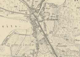 https://kartenhighlights.staatsbibliothek-berlin.de/wp-content/uploads/SBB_IIIC_Kart_N-3803_Blatt-24-von-1893_Ausschnitt-40000-dpi.jpg
1475
1553
AL
https://kartenhighlights.staatsbibliothek-berlin.de/wp-content/uploads/2020/11/logoSBB-SPK.svg
AL2022-04-03 01:00:312023-02-03 16:13:46Topographische Spezialkarte der Umgebung von Berlin und Potsdam, 1:25 000, 1858-1901
https://kartenhighlights.staatsbibliothek-berlin.de/wp-content/uploads/SBB_IIIC_Kart_N-3803_Blatt-24-von-1893_Ausschnitt-40000-dpi.jpg
1475
1553
AL
https://kartenhighlights.staatsbibliothek-berlin.de/wp-content/uploads/2020/11/logoSBB-SPK.svg
AL2022-04-03 01:00:312023-02-03 16:13:46Topographische Spezialkarte der Umgebung von Berlin und Potsdam, 1:25 000, 1858-1901
